WHERE IS VALTELLINA
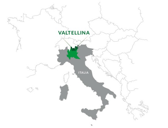
Valtellina is located
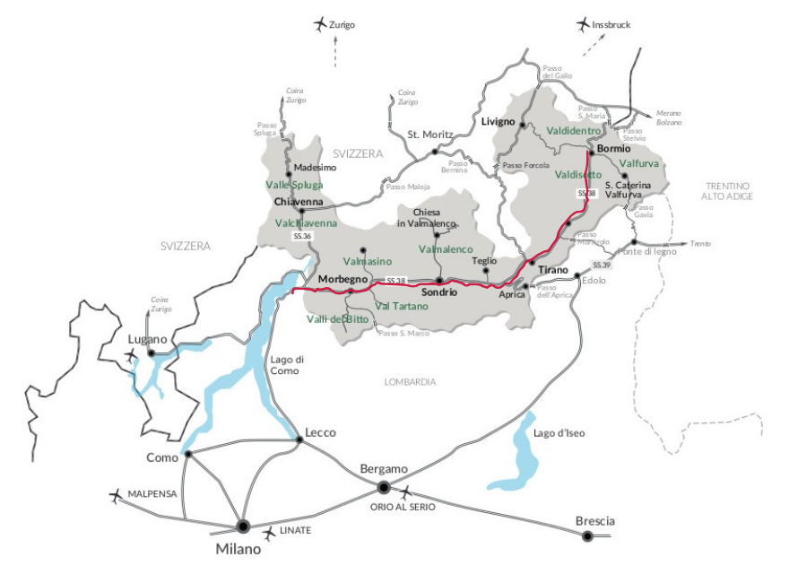
in the north of Lombardy, on the border between Italy and the Swiss canton of Grisons, and is the only major alpine river valley oriented east-west. It is 120 kilometers long and about 65 wide.
It consists of two main valleys: that of the Adda, which rises in the Bormio area, crosses Upper and Lower Valtellina, and flows into Lake Como; and that of the Liro and Mera rivers, which corresponds to Valchiavenna, from the Splügen Pass and Val Bregaglia down to Lake Mezzola.
PUBLIC TRANSPORTInfo and timetables:
www.trenord.it (train)www.stps.it (bus)www.busperego.it (bus)www.silvestribus.it (bus)www.ffs.ch
HOW TO GET THERE BY TRAIN
Milan - Tirano lineStops: Milano Centrale - Monza - Lecco - Varenna - Bellano - Colico - Morbegno - Sondrio - Tresenda/Aprica/Teglio - Tirano
Distance: 156 km (2:32 min). Change at Colico to reach Valchiavenna
Info:
www.trenord.itColico - Chiavenna lineDistance: 35 km (30 min)
Info:
www.trenord.itChur (CH) - Tirano lineMain stops: Chur - St. Moritz - Poschiavo - Tirano
Info:
www.ffs.chHOW TO GET THERE BY PLANE
The nearest airports are
Milan Linate, Milan Malpensa and
Bergamo Orio al Serio.
Other airports are Zurich (CH) and Innsbruck (AT).
HOW TO GET THERE BY CAR
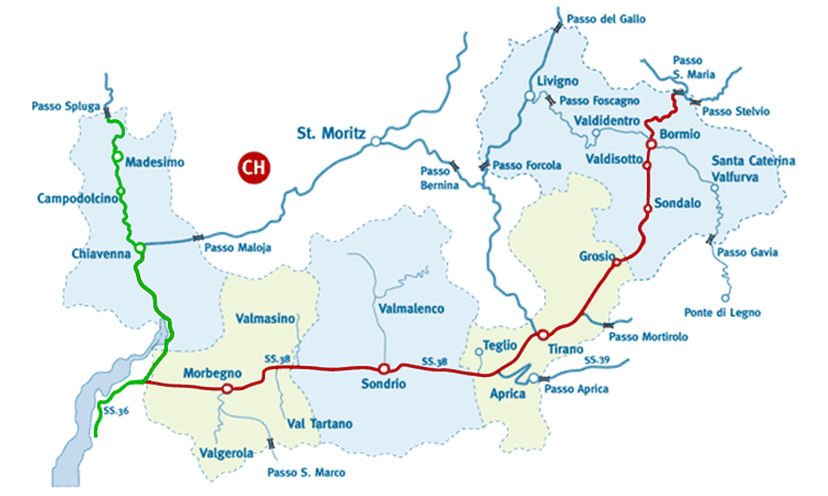
From the southFrom Milan, take the Splügen superstrada 36 (highlighted in green on the map below) which passes through Colico and reaches Chiavenna. Just after Colico, the Stelvio state road 38 begins (highlighted in red on the map below) which crosses all the main towns of Valtellina (Morbegno, Sondrio, Tirano) up to Bormio and the Stelvio Pass.
From the northLivigno and Upper Valtellina are reachable from Zernez (Lower Engadine) via the Gallo Pass (Munt La Schera tunnel). Valtellina is reachable from St. Moritz via the Bernina Pass, which leads directly to Tirano. Valtellina can also be reached from Val Camonica via the Aprica Pass or from the Engadine via the Maloja Pass which enters Valchiavenna. Other passes like the Gavia Pass from Brescia or Trento and the Stelvio Pass itself from South Tyrol lead to Valtellina, but are only passable in summer.
Alpine Passes open year-round
- Aprica Pass (1176 mt)
- Foscagno Pass (2291 mt)
- Gallo Border Crossing (1693 mt)
- Maloja Pass (1815 mt)
- Bernina Pass (2315 mt)
Alpine Passes open only in summer
- Splügen Pass (2115 mt)
- San Marco Pass (1992 mt)
- Mortirolo Pass (1852 mt)
- Gavia Pass (2621 mt)
- Stelvio Pass (2758 mt)
- Santa Maria Pass (2502 mt)
- Forcola Pass (2315 mt)
Verifica la situazione dei passi alpini
HOW TO REACH THE TOWNS...
Livigno and the towns of the Upper Valley
Livigno is reachable from Bormio via the Foscagno Pass or from Tirano via the Forcola Pass (closed in winter). From the north, it is also reachable from the Engadine via the Gallo Pass (Munt La Schera tunnel). Valdidentro, Valdisotto, and Valfurva are reachable once in Bormio by taking the branches of the SS38.
Aprica
Aprica is reachable from Brescia by traveling through Val Camonica and continuing over the Aprica Pass; from Milan, however, you must travel on the SS38 to Tresenda and then take the Aprica Pass.
Valmasino
Once in Morbegno, continue on the SS38 to Ardenno, from here you can take the road leading to Valmasino.
Valmalenco
Once in Sondrio via the SS38, you can take the provincial road leading to Valmalenco.
Madesimo
Madesimo is reachable from Milan by entering Valchiavenna via the SS36 and from Como via the SS340 Regina; from Switzerland, however, Madesimo is reachable via the Splügen Pass (winter closure) or via the Maloja Pass, then traveling on the SS37 to the destination.